Colchester – far more interesting than expected!

Saturday 25 April 2015 – Colchester.

My last post was all about a training walk on Box Hill for the Oxfam Trailwalker 100km walk I WAS going to be doing in July. As the ‘was’ suggests I am no longer doing the walk. After lots of serious thought I knew I was not going to be able to do this walk justice, I have done virtually no training since the start of the year and having done a 55km run I know what a 100km walk is going to feel like without training. I also know how my body feels now and punishing it further is not going to help. So, partly because it was unfair on my team mates who seem to have more time than me, partly as it would be unfair on El if I work half the weekend and then walk the rest, but mainly because I just don’t think I can do it I have pulled out. Luckily it was early enough for my spot in the team to be easily filled.

As always seems to be the case at the moment, the main reason for my life being so busy is work. I had a bit of a slump week this week so decided last night that I was going to take a day out. I have not had a whole day to myself since I went to Dartmouth before Christmas and I just needed some time when the only interactions I had with other humans was to order food and drink.

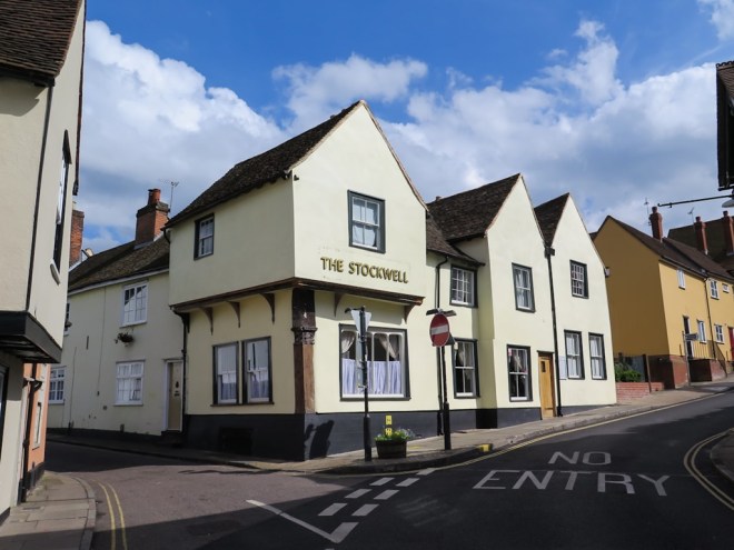
Not wanting to spend too much money, but still wanting to do something that got me out of London, I decided to go to Colchester in Essex. It wasn’t ideal, there was no beach for instance, but it was close enough, cheap enough and it had a castle and a river.

The other reason for visiting Colchester was there are frequent, direct trains from Liverpool St Station, Walthamstow also has a line to Liverpool St; home to Colchester was therefore not much more than an hour and no hassle at all. In my book that it always an incentive, inner-city travelling at the weekend is too reminiscent of commuting!

IMG_1445

From my limited experience it seems to be the tradition for old towns that are local centres to be surrounded by wide, busy pedestrian unfriendly roads that need to be navigated round and over if you are walking from the station. Colchester was no exception. I had no map, and had only vaguely consulted Google Maps on the train, but when I got to the River Colne and a path that led in the direction of a park I decided to leave the road behind and see where I ended up. Good (not) to see the river is (not) in good health.

IMG_1446

IMG_1447

My decision to leave the road was a good one as I found myself at the end of Castle Park, which was going to be my first stop.

Colchester’s main claims to historical fame, is it is Britain’s oldest recorded town (from AD 79) and also has the oldest Roman era city walls in the country. The Romans built their first British fortress in Colchester soon after the invasion in AD43, this became the centre of a colony which was then sacked by Boudica’s army in AD61. Soon after this event London became the capital of Roman Britain, who knows what would have happened if the sacking never took place ? The famous walls were built when the city was rebuilt from AD65-80 and are almost 4 miles long.

IMG_1449

 IMG_1453.jpg

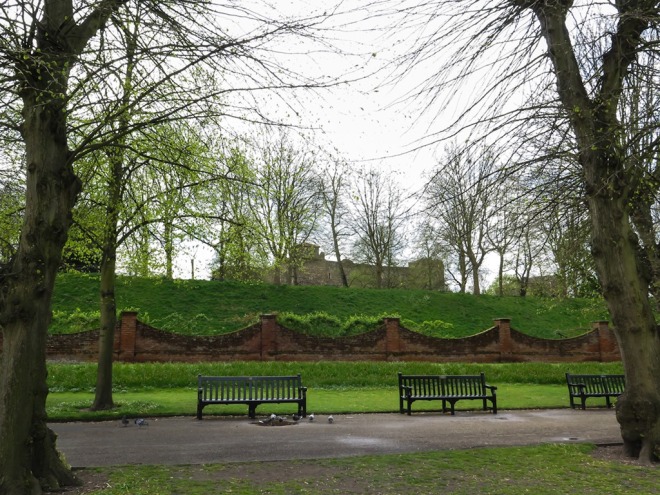
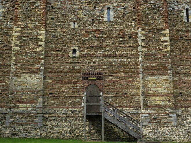
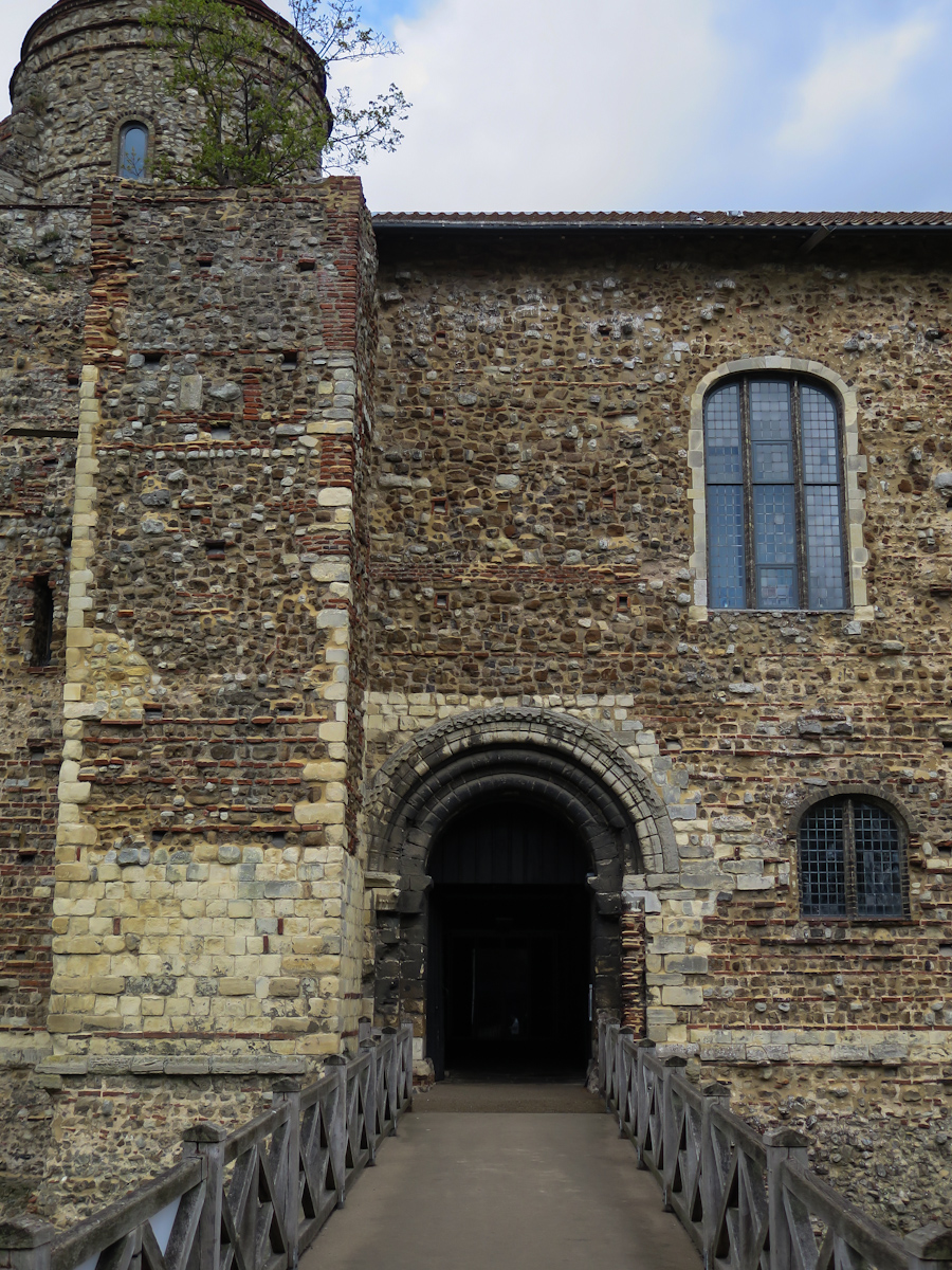
All that remains of Colchester Castle is the keep, the largest remaining keep in Europe. Construction was completed in 1100 and it was built on top of the old Roman temple. Like all such buildings it has a chequered history and while it was serving as a prison in the 1640s it was the home of the Witchfinder General, Mathew Hopkins. I imagine it was not pleasant to be under investigation.

IMG_1455

Like a lot of these old buildings it was built over a few decades using the various materials that were around, including stone and bricks salvaged from the old Roman buildings. I love the randomness of the window openings.

IMG_1456.jpg

IMG_1457

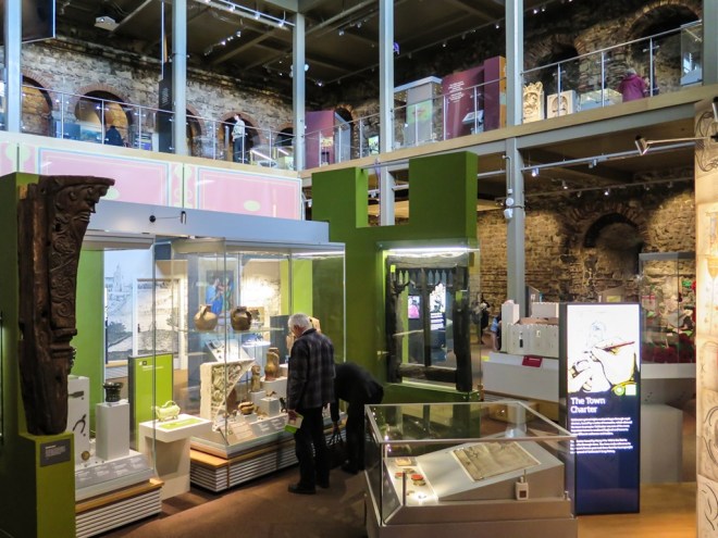
The castle has an excellent local museum inside, it was 7 pounds to enter, which I thought was good value for what was there. It was interesting and very child friendly with loads of (un-museum like) ‘Please touch’ signs on various activities. It was also pleasing to see that it was quite popular with the Colchester community with a few families looking around.

IMG_1464.jpg

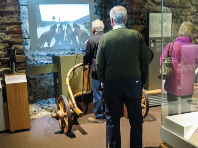
I really liked this chariot race game, these two couples were really enjoying themselves Smile Though I will say they dig hog it and I didn’t get a go. Though I am sure that if I had asked…

IMG_1460.jpg

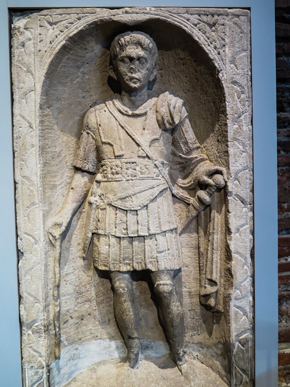
There were quite a few things of interest to see inside, I liked this tombstone of Marcus Favonius Facilis, who dies in Colchester soon after arriving in Britain in AD43. This is one of the earliest complete tombstones in Britain.

IMG_1462.jpg

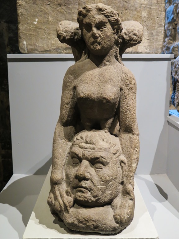
And another sculpture from the same period, the Colchester Sphinx.

IMG_1458.jpg

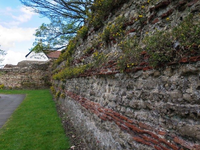
I left the museum in search of the next piece of history on my list, St Botolph’s Abbey. Not having a map meant I got a bit misplaced. But I did find this really cool section of the city walls – I love the weeds growing out of this almost 2000 year old piece of history.

IMG_1465.jpg

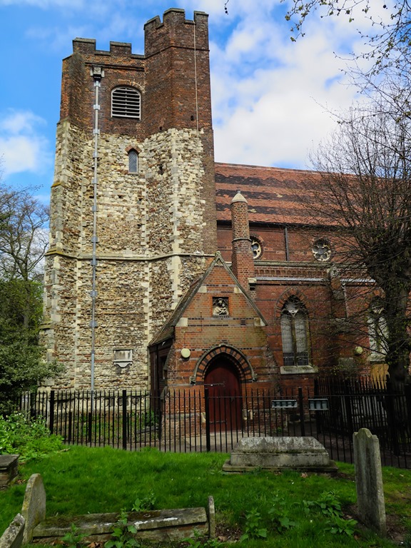
I passed by St Mary’s Church which I had read about in the museum. During the civil war in 1648, Colchester was besieged for many months by the Parliamentarians, the Royalists inside the town placed a small canon on the top of the church tower to fire over the walls, eventually it was hit by return fire and destroyed. When the church was later rebuilt the top of the tower was repaired in brick rather than the original Roman stone.

IMG_1467.jpg

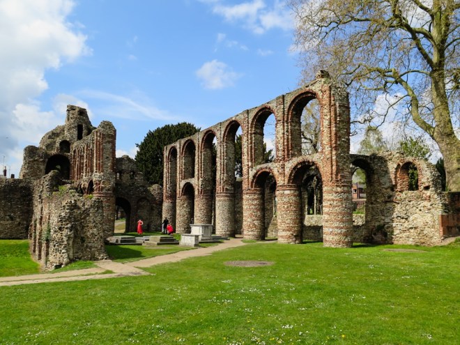
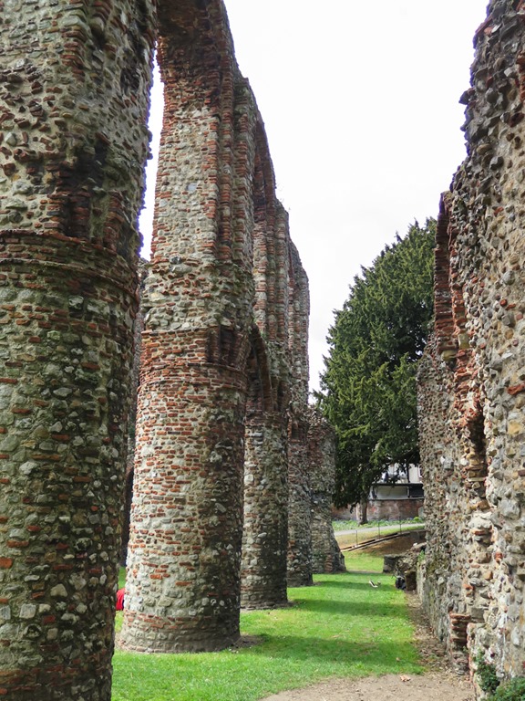
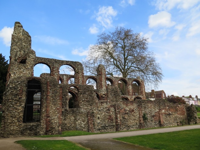
After a bit of faffing, some road side Google Mapping and eventually some random good fortune I found the ruins of St Botolph’s Priory. Unfortunately so had some people doing a model shoot who were hogging the place so, much as I like to take photos sans people, in this case I couldn’t and I ended up leaving in a minor huff.

IMG_1469.jpg

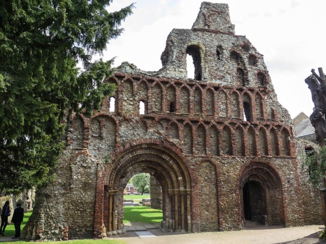
The priory was the first Augustinian priory in Britain and like the nearby castle was completed around 1100. A long with many of the other leading Catholic orders, such as St Marys in York, it was dissolved by the order King Henry VIII in 1536 and a number of the buildings were torn down. The church as was allowed to remain to serve the local people but it was destroyed during the civil war. it is quite pretty and peaceful.

IMG_1470.jpg

IMG_1472.jpg

IMG_1473.jpg

It was now past lunch time and my tummy was rumbling. When I was planning the trip last night, I had decided that I would find a nice pub to lunch in, drink a pint of decent ale, read my book, write some stuff, get myself organised with a few lists – I do love a list. Basically relax and unwind. But i couldn’t find a nice pub to lunch in. I did find the new art gallery though.

What a cool building, such a great contrast to the small old tower nearby. The gallery is very nice inside, big, airy and light. The exhibitions were not really to my liking, but the coffee and cake were fab.

IMG_1474.jpg

The last thing on my list of things to do was to find Bourne Mill. Resorting to Google Maps again I found my way quite easily to this old building on its man made lake on what used to be the edge of town.

IMG_1475.jpg

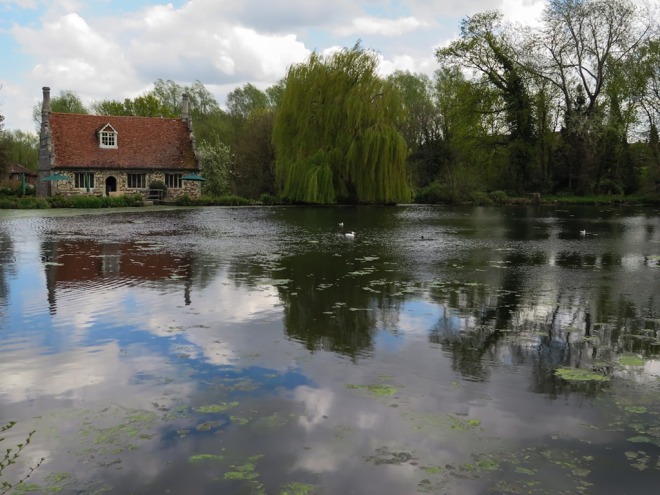
The building is managed by National Trust, so I finally got to use my membership card for the first time since I signed up two years ago. The mill was originally built in 1591 from stone left behind during the dissolution of the abbeys in 1536 and was built as a fishing lodge on a series of ponds made by the abbeys along a small stream that fed into the River Colne. It was converted into a fulling mill in 1640 and then into a corn mill in 1840 when the gables were added.

IMG_1478.jpg

IMG_1481.jpg

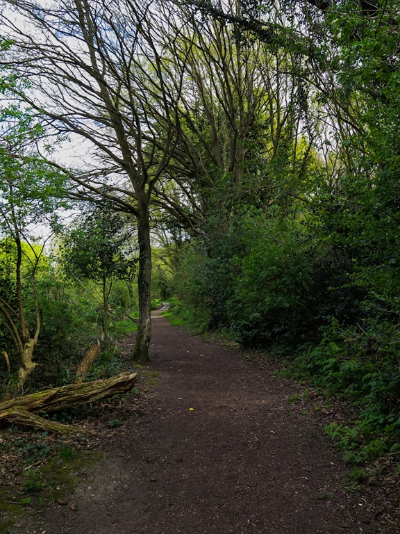
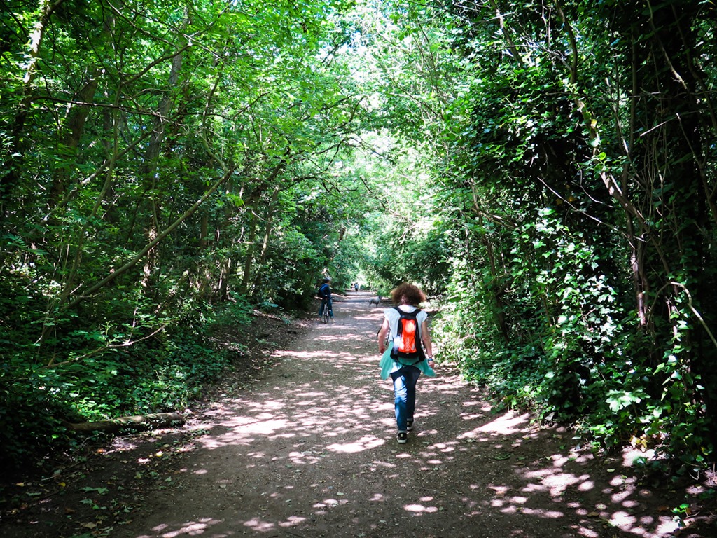
I followed path down the side of the very overgrown stream as far as I could towards the River Colne with the intent of following that back to where I started at the foot of Castle Park. The start of the stream walk was quite nice, at least it was quiet, but it soon popped out on to some busy edge of town roads.

IMG_1482.jpg

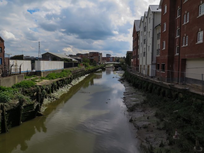
There was sort of a path following the river, though on this side of town it was not the charming river side walk I was hoping for…

IMG_1483.jpg

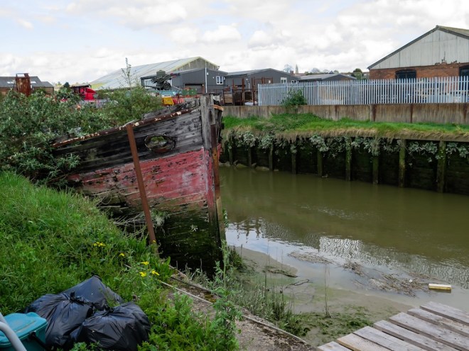
There is a ton of building going on around here, flats going up everywhere, I am guessing just to fuel the ever increasing fire for cheaper housing to meet the demands of those forced to leave London as it is now too expensive to live in.

IMG_1484.jpg

Crossing back into the centre of town, it is clear to see the line between the water haves and have nots, there is a weir at the edge of town that keeps the river running through the parks nice and high and full and far more attractive. Though I am assuming that is due to the river being tidal more than anything more subversive. Still it was nice to be walking through the park again once I passed through its gates.

I headed back up into the centre of town to try and find one of the council website advertised friendly village pubs, but all there seemed to be were large bars with tattooed punters drinking lager outside. Not my thing at all. I wandered around for a bit before giving up and heading back towards the station. My dream of an afternoon relaxing over an ale or two dashed, though I did stop for one in a not too bad pub, but there were no longer serving lunch so I didn’t stay. The one place that looked like it could have been a decent pub in the old Dutch quarter was closed.

IMG_1485.jpg

It had been a good day out, I enjoyed the old bits and the new gallery, it was nice to walk by a river, though it wasn’t a nice bit of river to walk by. It was nice to not have to talk or listen to anyone, and I could refocus myself a bit away from the madness and pressure of work.

I shall do it again.

The BEST thing that has happened in the last week is I have finally booked my many times postponed trip to New Zealand to see my family. As it now pretty much winter in NZ I have made it a quick visit with no ‘holiday’ time, just 10 days there and a lot to do. It is my grandson’s 1st birthday so I am really pleased to be able to be there for that, plus my oldest son is coming over from Australia as well. Double awesome, I get to see all three kids together!

A Box Hill hike

Friday 03 April 2015 – Box Hill, Surrey.

Easter Friday, a long weekend, Yay – and made even longer by having a much needed day off from work yesterday. Sounds pretty damn good to me !

I am part of a four person team that has signed up to do the Oxfam 100km walk on the South Downs in late July. With work being so busy and the weather not always being in my favour I, and the rest of the team, have not done a whole lot of training, and apart from one meet up in hotel bar to do some planning we have not actually done any walking together.

With this in mind we took the opportunity of a long weekend to get outside and do some walking in the hills just out of London, and Box Hill in Surrey ticked all those boxes. For some unfathomable reason the crazy people I am teamed up with decided that we would meet at Box Hill Station at 10:00 am, though it is not too far away it still meant an early rise on a day off work.

With public transport running reduced services and maintenance work going on all over the network I decided – wisely, to leave early and catch a tube to Vauxhall and get the train from the there to Box Hill, it was a slow journey but surprisingly reliable. I arrived at Box Hill to find one of my team mates already there at the station/cafe/bike shop. I availed myself of coffee, much needed coffee and a bit of cake while we waited. I really liked the station, yet for some reason I have no photo of it, I particularly liked fact it had a bike shop in it, and coffee was served surrounded by bikes

We were on the way soon after the others arrived, and immediately took the wrong turn out of the station. We were going to do the Box Hill Hike, there was a map on the internet with directions and everything nicely laid out, but all from the car park at Box Hill, no mention of the station at all, and no signs from the station either. I though this was rather poor. We realised fairly quickly we had gone the wrong way and were soon heading off roughly in the right direction.

It is a reasonable walk from the station to the official start of the Box Hill hike at the centre car park. It is a nice walk though. It is really nice to be out in the country!

IMG_1419

IMG_1420

The walk starts at the bottom of one of the many climbs up and around the hill, though we were soon heading up, and I surprised myself and had no issues with the climb at all. Ok, we are not talking Everest here, but it does go up a couple of hundred metres and when the escalator out of Holborn Station is your biggest regular climb, then even half that ascent that can be a challenge. I do not take prisoners on a climb either, so I did have a wait at the top…

There was not much of a view though.

IMG_1421

We soon found the car park and the official start of the walk, and once under way the clouds started to lift and the day became quite reasonable. There was a point as we were walking to the start when I was wondering whether we were going to be able to remove woolly hats and rain coats at all, but the cloud eventually lifted and it turned out to be not too bad a day – and it even warmed up a bit.

IMG_1422

Before we left I had done a bit of research into the park and definitely wanted to see Broadwood’s Folly, built in 1815 on the hill above the Broadwood family home. The Holm Oak growing through the middle is not native to the area and the seed may have been dropped by a passing bird. I thought it was quite cool…

IMG_1424

IMG_1428

IMG_1426

There was a lot of up and down on the walk, as you would expect from a walk with Hill in the name! I liked it, I am not really a fan of all the flat stuff, and it was really nice to not be walking on roads or surrounded by cars either. This would be a great run, and we did see a few runners out as well as a lots of other walkers.

IMG_1429

The church at Mickleham Village.

IMG_1431

Back up on the tops again there was some quite nice forested areas, nice and mossy after the winter.

IMG_1432

There was also this long stretch called the Mickleham Gallops, where horses were trained for races at the nearby Epsom track.

IMG_1434

And at the bottom of the hill, and the start of the next climb – a rather nice cottage, the sort of place I used to fantasize about living in until the realities of living in an old house in the country sank in. Though this one I think would make a good location for a haunted house story.

IMG_1435

And then it was back up the hill again….

IMG_1436

Once over the top of this climb we were almost back to the start, and a slow wind down back to the station. We arrived just before the train so ran up and over the bridge and for some reason the train didn’t stop like it was supposed to. It was then back over the bridge and into the cafe for coffee and cake while we waited for the next train. The walk took just under four hours, including a stop for some lunch, and the odd break at the top of the many short climbs.

It was a really good day out. I took my Garmin watch and recorded that we did 68kms and we walked back to London. I must have forgotten to turn it off… 

My quads ached the next day !!

A visit to Windsor Castle.

Thursday 02 April 2015 – Windsor.

I have never been to Windsor Castle; at least not as an adult. It is entirely possible that I visited as a child, but the only memories I have of it are more recent, and mainly come from the TV and movies. As a nearby and important castle, it has been on my ‘must visit’ list for a very long time.

Things have been really manic at work for quite a while now; the implementation of a new system was always going to be intense and stressful and it certainly was all of that and more. With all the time spent working I have not spent any time even thinking about trips away or adventures – big, small or even micro. So when El said she was taking the two days before Easter off of work and suggested we take a day out to go somewhere, I jumped at the opportunity. Actually, what I did do was ponder it for a few days, ask my boss for the Thursday before Easter off and crossed my fingers he would say yes. Which he did.

A day was not going to give us time to do much so we decided to nip down to Windsor the night before and get into the castle before the day got too busy – and then I could finally knock Windsor off of the list.

I will say the week had been pretty average, and average was the best it got before I snuck out the door early on Wednesday to power walk my way to Waterloo Station to meet El and the 4:58 train to Windsor and Eton Riverside. With a few crappy work emails on the hour long train ride I arrived in Windsor with a bit of a grump on. Luckily El had booked us a nice hotel who gave us a free glass of prosecco each on arrival. This certainly helped to smooth over a few of the bumps in my day.

After settling in we went for a walk out in to the early evening for a quick explore of Windsor. It is a lot smaller than I expected and is totally dominated by the castle.

Windsor the town as it is now known was originally known as New Windsor, with the first town of Windsor renamed Old Windsor when the new town was built around the castle in Norman times. Windsor means ‘winch by the riverside’ in old Anglo-Saxon. The town had its boom time in the early 16th century but faded after the reformation and the death of King Henry VIII soon after. Outside of the castle there was really only one building of interest.

IMG_1376

The well wasn’t particularly interesting – though the machine gun toting copper in the background did highlight the seriousness of the castle, the Queen was not in residence at the time.

IMG_1378

I did like the sense of humour in the sign on the well though.

IMG_1377

This is obviously the Long Walk – not the long cycle, or push.

IMG_1379

IMG_1380

Viewed from the other end you do get a view of the castle.

IMG_1382

The rest of the town didn’t really inspire, though to be fair to Windsor, I was not in the mood. On another day it could have been great.

IMG_1383

We did have a very nice meal in a small French bistro on the high street washed down with a very tasty bottle of viognier. With a whisky before bed, my day was certainly finishing far better than it had started.

Not having to rush out of bed on Thursday was a real blessing, and following up the late rise with a tasty full English breakfast was even better!

We made it out into the day just before 10:00, and were quite surprised at the amount of people the castle had already attracted. As I said, the castle dominates the town, and it was literally less than a hundred metres from our hotel to the entrance road of the castle.

IMG_1384

IMG_1386

IMG_1387

The castle was originally built during Norman times to dominate access to a strategically important part of the River Thames, but became more important under Henry II in the 12th century. It is the longest serving royal palace in Europe and is still used as one of the main royal residences today. It is big, it is well preserved, it is awesome in its construction and I found it the most boring castle I have visited so far. It was all a bit disappointing as I had been looking forward to exploring it for a long time.

We had to queue for a while to get in, and pass through airport type security. I sort of understood this given its relevance as an active royal residence. It was expensive, at just over 19GBP each.

It did have its cool bits, I am a sucker for big walls and battlements. It wasn’t even too crowded, busy but tolerable.

IMG_1388

IMG_1389 

IMG_1391

But there was not much to see – there was a moat room. I passed two doors telling me so, I don’t know what was on the other side of the doors though.

IMG_1393

And we were all funneled along certain paths, no aimless wandering around and most disappointingly of all – no walking on the battlements.

IMG_1394

We did visit the royal apartments – significant Georgian buildings, with some lovely art and lots of posh furniture.

IMG_1399

No photos allowed though. But I did sneak this in an oasis of calm in the drawings room.

IMG_1400

And this one out the window while the trooping of the colour was on.

IMG_1401

I sort of liked the Royal Apartments, though it was a bit sterile and knowing that part of this palace is actually the home to a very select few while so many live in poverty does make this seem somewhat obscene.

IMG_1402

Back outside we caught the end of the trooping of the colour and the not small number of fellow visitors gathered to watch. I would hate to be here in peak time, it must be truly, awfully busy.

IMG_1404

IMG_1405

IMG_1406

While the crowds watched the display I took a quick look around the outside of some of the buildings we were not allowed to enter.

IMG_1407

IMG_1409

IMG_1408

Our last stop before leaving was St Georges Chapel.

IMG_1413

Like the rest of the interior we were not allowed to take photos inside, which was a real shame as there are not many places with so many royal tombs inside, including some famous one like Henry VIII.

And that was our visit to Windsor Castle over, No wall walks, no poking around, clambering over ruins. No photos of suits of armour, old canon or other historical knick-knacks that occasionally catch my fancy. The fact there are more shops than toilets sort of sums the place up for me. A tourist rip off. It was a bit of a sham really, the Tower of London does this much better.

After such a big breakfast we did not fancy lunch, but we did stop for coffee, cake and a sit down before picking up our bags from the hotel and wandering back down to the station.

The view at least is pretty spectacular from anywhere in town.

IMG_1415

IMG_1417

IMG_1418

York, lovely York, part three.

Sunday 07 February 2015 – York.

A quick update as to where the last post left us…  We had had a very enjoyable morning and had just finished a pizza lunch and a nice glass of wine after visiting all the parts of central York that we were going to be able to do with the time we had.  This after we planned to spend some time walking around the museum gardens before returning to the hotel for a rest before dinner.

I had been looking forward to visiting the gardens as they contain some really interesting ruins and I am all about the ruins!

The gardens were orginally created in 1828 when ten acres of the grounds of the former St Mary’s Abbey were gifted by the royal family to the Yorkshire Philosophical Society for the creation of a museum and the development of botanical gardens.

Our first stop was St Leonard’s Hospital. At its peak in the middle ages it was the biggest hospital in England, holding up to 240 patients. I did not realise that hospitals had been going for such a long time !  Construction started in the 1220’s and it was closed during the dissolution of the monasteries under King Henry VIII in the late 1530s.

IMG_1278

IMG_1286.jpg

IMG_1287.jpg

We followed some of the remaining sections of the old city walls around to the Multangular Tower, the best known of the remaining Roman towers in the city. It was built in the late 4th century to hold a large catapult and it has ten sides, hence its name. You can quite clearly see all the different materials used to construct and maintain the walls over the years.

IMG_1279

Inside the tower there are five stone coffins from the Roman period that were found in other locations in the city.

IMG_1283.jpg

This picture, sadly the light was poor, shows the different levels of wall built over the centuries, form the original Roman wall started in 70 AD, through the dark ages up to the 10th century, past the Norman period and finally Medieval times in 13th.

IMG_1290

IMG_1292.jpg

This led us over to St Mary’s Abbey – which I have seen loads of photos of and particularly love as a set of ruins. A church was first built here back in Norman times in 1055, though the ruins here are from a modifications starting in the late 13th century. Like the hospital the abbey was pulled down during the reformation in 1539 and a lot of the stone was used elsewhere. I loved them…

IMG_1294.jpg

IMG_1295.jpg

IMG_1297.jpg

IMG_1298.jpg

IMG_1299.jpg

As the afternoon started to fade we headed back to the hotel, walking up the road outside of those ancient abbey walls.

IMG_1302.jpg

We bought a glass of wine in the bar and took them back to our room for a rest after quite a long day of walking. Later on we noticed a wonderful sunset out the window, so I grabbed my camera and took a very fast walk back to St Mary’s Abbey. I just made it in time to grab a few images – and left the tripod in our room.

IMG_1303.jpg

IMG_1309.jpg

IMG_1313.jpg

IMG_1316.jpg

We had booked dinner at El Piano a highly recommended vegetarian restaurant and it was really full, it is a casual cafe style restaurant with really nice food and wine. We left very full.

I took the camera as I wanted to get a final photo of the Minster.

IMG_1322.jpg

On Sunday morning, we didn’t really rush out of bed, but we were still up early enough that we had to wander around again trying find somewhere to get breakfast. Even though we had a great breakfast the day before we wanted to try a different place. It took a while but we did found an open cafe and they did do a really good full English – I over ate yet again. On the way we passed through the Shambles again, and so much quieter than yesterday!

IMG_1323.jpg

Hello Smile

IMG_1325.jpg

And then that was it, back to York station and its famous old clock.

IMG_1327.jpg

IMG_1328.jpg

And back to London, looking out on the loveliest weather of the whole weekend, via another dirty window…  It was another good train ride back, fast and on time, and I didn’t eat as much as I did on the way up!

IMG_1339.jpg

We loved York, it is a really nice town, there was a good vibe and so many things to look at. if you live in England or are planning to come here on holiday I highly recommend a visit.

Half a day in the lovely city of York.

Saturday 07 February 2015 – York.

Our room at the Churchill did not include breakfast so we decided to head out earlyish and get breakfast in before goiing to the minster for opening time, and hopefully beating any crowds. York is a very popular tourist town and York’s premier attraction is York Minster. It may look like one but it is not called a cathedral, so thanks to Wikipedia – A minster is a church that was established during Anglo-Saxon times as a missionary teaching church, or a church attached to a monastery. A cathedral is the seat of a bishop, because his seat, or throne, is called a cathedra.

The hotel was under half a mile from the minster on one of the main roads into town, and just outside the city walls. Though the walk in to the ‘old’ part was still pretty damn nice, with a mix of Georgian terraces and little bits that are significantly older.

 IMG_1192IMG_1193IMG_1194Once through the city wall at Bootham Bar – a toll gate from the thirteenth century, we were rewarded with our first day time view of the minster.

IMG_1195IMG_1197Even though it was 9:00 am on a Saturday, finding somewhere open for breakfast was rather tricky. as nothing appeared to be open. We did find the place where Guy Fawkes was born – which was a surprise as I had no idea, he was from York I just assumed he was born in London – my London centric view I guess.

IMG_1201We finally found somewhere for a very nice breakfast, and damn good coffee as well, good enough to have a second to take away as we carried on strolling around killing some time before the minster opened. The coffee did not come from Coffee Yard though, there was no coffee in Coffee Yard at that time of day, I had to duck to walk down this alley leading to old Barley Hall.

IMG_1202IMG_1204We popped out on to one of the main shopping thoroughfares of York and I took the opportunity to take a picture while it was relatively quiet, as you can see the streets are narrow, the buildings sort of lean in and it is all quite nice. IMG_1205I cannot remember the name of this building, it is behind the minster and I recall it was part of a school. The pillar in front is from the original Roman great hall and was discovered during excavation work in 1969. It was erected as a monument to celebrate the 1900th anniversary of the founding of York in 71AD.  A 1900th anniversary, wow. That is centuries older than the discovery ofNew Zealand.

IMG_1207The Emperor Constantine.

 IMG_1209It was now opening time for the minster and time for us to head inside.

IMG_1208We were a little disappointed at the cost of entry into York Minster, 15 pounds a head to enter a church building is a little steep in my book. I understand that running a building of historical significance costs an awful lot of money, but the church is hardly going broke.

There has been a church on this site since the early 7th century, though numerous fires and sackings, and the almost complete destruction at the hands of the Danes in 1075 meant the current building was started in 1080. The bulk of the gothic style was started in the 1220’s. There has been renovation work on the building off and on ever since. It is a pretty cool building, including a major and long term piece of work on the stained glass window. It did feel a bit soulless to us, unusually so. Normally we love the feel of the great cathedrals.

IMG_1215It was still pretty and interesting in place and I did take a few photos inside.

IMG_1216IMG_1219IMG_1220IMG_1221IMG_1222The crypt was quite interesting with some lovely old Norman artifacts, including this Doomstone, which depicts the entrance to hell and sinners being tortured and consumed. Nothing like a bit of churchy forgiveness…

IMG_1229IMG_1226I also really liked this 15th century carving of St Anne teaching the virgin mother to read.

IMG_1228IMG_1231We left the minster and walk around and through the gardens at the back.

IMG_1232IMG_1235Back out into the streets of York and off to walk some old city walls. York has the most extensive network of remaining city walls in the UK, something I did not know until we arrived yesterday and something I found very exciting. The walls were first built by the Romans, starting from their earliest occupation in 71AD, though they fell into disrepair and were largely rebuilt under the Danes and into the 12th and 14 century – and these are the walls we walked on today. We entered the walls at Monk Bar, one of the many gate forts along the wall.

IMG_1239IMG_1240IMG_1242IMG_1243The walls do not fully surround the city, there are numerous gaps, including the rivers. There was a river side walk down the side of the Foss, it had all the charms of Regents Canal in London. Not saying that is good or bad !

IMG_1247Back in to town, we found ourselves at Whip-Ma-Whop-Ma Gate. The shortest street in York. In this case gate is a corruption of the Viking word Gatta – which means street. It runs the width of the church…

IMG_1248Our next stop was Clifford’s Tower, the last remaining part of York Castle, which was built under order of the Norman king William I. It was partially destroyed in 1648 after a major explosion, but was used as a prison until 1929. IMG_1250IMG_1255There was a fee to enter the tower, so we flagged the opportunity to go inside, but we did walk up and take a photo from the top of the hill, before walking down to the Castle Museum.

IMG_1256IMG_1257This also had an entry fee, so we flagged that as well, though we did stop for a very nice coffee and disgustingly sticky and oozy custard slice in the museum cafe – it was magic.

We went down to the River Ouse and walked along the river side for a short while before heading back towards the city centre and our next stop, one of York’s premier tourist spots – the Jorvik Museum, where we had planned to pay the entrance fee. On the way we spotted an extremely rare thing – a closed down Tesco Express. Wow! Never thought I would see one of these, I didn’t even know they existed.

IMG_1264We also walked past The Stone Roses Bar, much as I loved the Stone Roses, I don’t think I would want to go into a bar named after them.

IMG_1265The Jorvik Museum was kinda cool, it is built on the site of an archaeological dig from the late 70’s that discovered a series of streets and houses from the ancient Viking community of Jorvik. The museum is like a history lesson on a Disneyland ride. Sitting inside a ‘time capsule’ we took a ride through the streets of the ancient Viking capital and were shown what daily life was like back then, it was part amusing an part interesting. I really liked it. Photos were not allowed, but I snuck one anyway.

IMG_1272It was lunch time after the museum so we started looking for someone where to eat, we had a bit of a list of places to try and started trying to find a couple. On the way we took a walk through The Shambles, one of the oldest streets in York, but rammed full of tourists.

IMG_1205We ended up not going to one of the highly recommended places, though we did book one for dinner – and had a pretty damn good pizza on the way….

The afternoon is coming next!

Last chance to see – a bit of Camden disappearing.

Sunday 25 January 2015 – Camden.

The second in a two part series of recent London street art, this time from Camden.

Last week I saw a tweet from Inspiring City, one of my favourite London street art bloggers, advising that the Hawley Market in Camden had just been closed down, at very short final notice to the stall holders. I guess they knew it was coming as the site had long been marked down as the location for a new school along with the inevitable flats that I am sure no-one from the area will be able to afford.

Over the past few months the permanent market stalls had been painted over by a  variety of both local and overseas artists, with some really nice work being completed, so it was a bit of a shock and a shame to see them all going.  As I mentioned in yesterdays post there are now large tracts of London slowly being bulldozed into oblivion for the sake of ‘progress’. Progress for whom I am not sure.

El and I wanted to go for a walk before a two year anniversary lunch in Islington, and decided to go to Kings Cross on the tube and walk to Islington via a big detour to Camden – almost in the opposite direction.  We walked along the side of Regents Canal, I haven’t been along here for quite a while, but the whole canal system has to be a long and skinny favourite part of London. Even this section just behind Kings Cross station in central London looks like it could be located in a small rural town, apart from the BT Tower sneaking it’s way into the horizon.

IMG_1150IMG_1151
The Hawley Market runs along the side of the canal and is now all fenced off. There are a lot more huts painted than there was the last time I visited, maybe Captain Kris is showing what he thinks if the closure.

IMG_1152It is also a shame to lose this from Gnasher as well.

IMG_1153‘Save the Bees’ from Louis Masai. Both Louis and Gnasher did some work a couple of summers ago on an underpass in Walthamstow Marshes and thankfully there is no plan, yet, to full the marshes with houses.

IMG_1154We walked around to the far side of the market on Hawley St, passed a soon to be unloved Hunto.

IMG_1155Down Selbourne Rd there was a new mural from Lost Souls Crew

IMG_1157And this cool wall from Dan Kitchener – I am hoping Dan will be painting in Walthamstow fairly soon, there has been a bit of painting going on lately organised by a local group Wood St Walls.

IMG_1156There was also a new piece from Mr Cenz.

IMG_1158
Down the side of the railway arches there were a couple of pieces I haven’t seen before, one from Jimmy C.

IMG_1160
And one from an artist who I am vaguely familiar with but cannot pin a name on right now, but I really liked this.

IMG_1159
I was hoping to have a look at the houses along here, as a number have been painted prior to demolition. However, the road is now closed and the crews are moving in. I am not entirely sure if this section is part of the school/flats project or just an excuse to tie in with the school build and ram up some more flats. I guess the one tiny tiny benefit of the closure of these houses was that they became temporary legal canvases.

IMG_1161A door from D7606

IMG_1162A big Himbad

IMG_1163A bit of fun from Zadok

IMG_1164A Je Suis Charlie mural from Tom Blackford.

IMG_1165Dan Kitchener

IMG_1168And finally this very nice mural from Irony.

IMG_1174It was then time to head towards our lunch reservation at the posh fish and chip shop in Islington, almost an hours walk away.  Like Shoreditch yesterday, a small part of town is disappearing, I am sure there are many who will say we need to the housing in London and it is only a small section, but I fear it will be a death by a thousand cuts and all of a sudden we will realise that all the bits that made London the cool city it is will be gone.

“No Hope. Turn Back.” A street art walk in Shoreditch.

Saturday 24 January 2015 – Shoreditch.

It was a glorious winter day with clear skies and a reasonable temperature,  out of the wind it was quite nice, but there was a real bite of wind chill, especially in the shade. It was not a day worth wasting and with El meeting a friend for lunch I took the opportunity to re-visit some old haunts and go look at some street art. I have not been to Shoreditch since early November and I was intrigued to see if much had been going on since, I was fairly disappointed last time I was out. I had been reading stories of walls being knocked down and buildings closed and it was time to go and see it myself, plus it was a good excuse to do a walk through of Rough Trade and see if there was any essential vinyl to purchase. There is always essential vinyl to purchase as it happens, and today was no different!

My first stop was Rockwell House, I have been to a few parties and live painting events on the roof of Rockwell House over the past couple of years and it the studio home of Jim Vision and End of the Line – whose work I really enjoyed. Rockwell House has now been closed and will soon be demolished to clear space for a series of new offices being built across this end of the east end – the part where it brushes up against the city. We obviously need more space for bankers, lawyers, consultants and all those other vital cogs to the UK economy, no room for creatives in this modern world…

The cowboy painting by American artist El Mac has graced the side of Rockwell House since 2011 and is one of my favourite works of art in the area, it will be a shame to see it go – though I guess the transitional nature of street art is one of its greatest facets. The 13 Coins piece is quite new.

IMG_1130

On the far side of the building there were quite a few painted walls, though unfortunately there was almost also a corresponding amount of cars to cover up the art. There were a couple of pieces exposed, one by Antony Lister – who I last saw hanging in a gallery with price tags way out of my league.

IMG_1129

I believe this is by Jim Vision – I haven’t seen too many faces by him, really good too.

IMG_1128

My next stop was the Leonard St Carpark, hoardings have been up here for a while so I knew there was some demolition planned, but it is a shame to see things disappearing. Nice hoarding by Boxhead though.

IMG_1131

Round the corner from the carpark is Blackall St, which was a narrow one lane road that was covered in stickers, paste ups, graff and other painting. It has always been a favourite place to visit, but I was totally shocked to find that one side of the street was completely gone!

There are hoardings around the site, which have all been painted, but it is not the same… I guess we are lucky that the hoardings are painted as so many in this area are not.

IMG_1133

IMG_1135

A little bit of Blackall St style.

IMG_1134

As I walked back towards Leonard St I caught a flash of a colour out of the corner of my eye so wandered off towards Scrutton st where I found this lovely new bird from Bailon.

IMG_1136

And this possibly older shutter from Bailon, Dr Zadok and Sokar.

IMG_1137

I wanted to see the Amara piece on the back of the Villlage Underground so headed back the way I came and found this quite cool piece by Jimmy C.

IMG_1138

I was then shocked again to find the carpark at the back of the VU being dug up as well,, not that pedestrians were ever allowed in there to take photos, carpark security wouldn’t allow it. I sort of understood the situation , lots of cars and allowing people to wander around obviously comes with some security risks, but there were some good walls behind the security and I never got to see them properly. Still won’t I guess.

IMG_1140

The Amara piece was pretty cool.

IMG_1141

Back over on the Brick Lane side I came across this from Jim Vision, I think given to what has been happening to the inner East End lately, ‘no hope’ is an apt message.

IMG_1142

The small car park off of Brick Lane is a regular spot for artists and viewers, though I have never seen this sign before – not that I come to the area much on a Saturday, I hope it doesn’t mean that this spot will be black listed as well.

IMG_1144

The street art tour has become big business and I saw at least four large groups in the Brick Lane area in the short time I was there, these two large groups in Hanbury St effectively stopping anyone from seeing or photographing any of the street art. Luckily there was not a lot of change since the last time I was there.

IMG_1145

Though I kinda licked this, but have no idea who it is by.

IMG_1146

There was not a lot else to see so I popped into Rough Trade for a coffee and a record purchase or two, Hookworms – The Hum and Disappears – Era. On my way up towards Broadway Market where I had decided to go for lunch I found this fun piece from Graffiti Life, and that was the last new bit of art I saw all day.

IMG_1149

Seeing so much change to the Shoreditch area was really disturbing, so much of the city is disappearing to allow new offices and apartments for wealthy investors to buy and not live. Soho is now under threat and the old ‘Tin Pan Alley’ – Denmark St has been given notice for demolition. Tomorrow El and I are going to Camden and there is a whole load more heartache there as well. All the good bits of London will be gone, probably before me.

A new year shakedown Epping Forest mountain bike ride.

Sunday 04 January 2015 – Epping Forest.

First ride and first post of the new year, I am hoping to be able to keep up with both.

My Christmas and New Year were both enjoyable, El and I stayed around home for the most part, though we both worked a couple of days between Christmas and New Year. It was a welcome break from work, it did get a bit stressful towards the end and after so long off work, four months seemed a long time between holidays. I cannot say I am looking forward to going back tomorrow, but at least I am relaxed again – reasonably so anyway.

I missed my family over Christmas, in the end I did not even get too see them on Skype which was a real shame, and apparently they had a good time without me! I did enjoy my time with El and her boys though, lots of food, some wine and not too bad TV made for a good couple of days and it was lovely being able to share it with them again.

I have made a couple of small life decisions in the past couple of weeks, firstly I am growing facial hair again, I won’t go full hipster beard, just a small winter warmer and an opportunity to not have to shave for a few weeks, my most hated chore. Secondly and more radically I have deleted my FaceBook account. I have been there, almost since the beginning, but have finally gotten sick of it and the fact that it intrudes so much into my life, mostly because I let it I will say. Anyway I will see how it goes with a FaceBook free life. It can only be better.

It was a pretty lazy holiday period, though we did walk, I have not run since before Christmas and have not been on the bike since late November when I did my first bike event in years. An event I was really poorly prepared for and subsequently did not enjoy as much as I should have. Not that that kept me off the bike though – laziness and an ever extending stomach kept me off the bike.

Last week, local mountain bike enthusiast, Tony from Walthamstow Cycles, sent an email round about a group ride in Epping Forest this Sunday and it was the impetus I needed to get off my sorry ass, get the cold gear out, lube the chain, pump up the tyres and get ready to go out for a ride – even if it was supposed to be in a -1 freezing fog.

Fortunately, on the day it was comparatively nice; with grey skies, a light mist and a positively warm zero degrees when I left home to meet the crew at 8:30. There was supposed to be eight riders heading out today and surprisingly everyone was there and even more surprisingly everyone was there on time, in fact we actually left the meeting point early. This is not something I am used to at all. I like this group already!

We rode off from Beacontree Ave into Walthamstow Forest, a small section of forest that links up, via a few more small sections into the broader Epping Forest. You know it is cold when the frost covered grass is crunching under your wheels and the puddles in the mud are iced over. Luckily once we got under the trees the layers of mud were not so iced over, just slushy and boggy and clingy. Did I say luckily ?

I had tossed a camera in my bag on the off chance I would get a chance to get some photos off a foggy and damp Epping Forest, but as expected the opportunities were few and far between, this was a bike ride, not a photographic mission!

We rode through to Epping Forest by a long and winding route, trying to avoid the worst of the mud and wet areas from a very full River Ching. There was some quite tasty single track sessions that I am unlikely to ever find again. Once in Epping Forest itself, it was ‘good’ to ride up Pole Hill and away from the wet land. It is the highest point in the forest, though at a massive 91 metres it is hardly going to be much use for hill training. But we did take a break at the top and I got to take a couple of pictures. Sadly there was no view….

IMG_1103IMG_1101The best bit about riding up a hill is getting to ride back down again, I rode this trail on my first ride in the forest but was never able to find it again, it was a lot more fun when there was some grip, but even slippy and slidey it was still a load of fun and one of my favourite trails of the day – not that there was a bad trail ridden….

IMG_1102We had another break for some running repairs as we headed across the middle of the lower half of the forest, and I again took the opportunity to take some photos. The forecast had said that there would be an increase in fog over the morning and they were not wrong for a change.

IMG_1106Our next stop was Strawberry Ponds, a lovely area of the forest that I would like to visit again and take some photos at. A location I have now lined up for a session if it snows, though finding it would be a challenge. It is a beautiful spot and the middle of the pond was very much covered in ice.

IMG_1109IMG_1110After almost three hours of riding we took a much earned rest at the tea shed at High Beach, coffee and the famous bread pudding was very well received. The riding had been quite hard, we were hardly setting a rocket pace, but the mud was constant and we were either sliding around, splashing through puddles or grinding through thick sucking mud – the worst kind. I was not feeling too bad, mid-pack in fitness so able to keep up easily enough and with steady riding I had not gotten too hot or too cold – with the exception of my toes which were freezing. New socks are on the shopping lost.

IMG_1111We took a few short cuts on the way back towards home, scooting quickly down some of the more established paths. Losing half the group as we went. It was a bit of a slog back across the flat areas with a some real bog grinds and a crossing of the River Ching (in reality a small stream) when we came across an impassably flooded section of track.

Tony offered us the use of his pressure washer to rinse the bikes down, along with a quick chain lube before I rode home after almost 28 kms of mostly single track riding. My new bike – a Genesis Latitude, was perfect for this riding, the bigger wheels were great in the mud and the bike is so well balanced, I am really glad I bought it.

IMG_1113It was a great morning out, a hell of a lot of fun with a good group of riders. I earned the sausage, eggs, chips and beans I had at the local cafe for lunch ! Thanks Walthamstow Cycles !!

Ruined villages, WWII tragedies and some nice scenery.

Tuesday 23 December 2014 – Dartmouth, Devon.

After all that walking yesterday and feeling quite weary when I turned the light off at 10:00 I fully expected to get a pretty solid sleep in, but sadly that was not to be, and I just dozed off and on all night. Maybe it was the two hours of photo editing I did before sleep!

I was up at 8:00 again and spent half hour writing part of a blog post on yesterday after breakfast before I packed up and headed out the door. My plan was to catch the bus to Torcross and walk to Hallsands and back. The B and B host could not find a bus timetable before I left which turned out to be a mistake as I missed the once an hour bus by five minutes because I detoured on a walk around Dartmouth on the way to the bus stop. Which meant forty five minutes in a cafe waiting for the next one, at least I got to drink a decent coffee.

My B and B is next to the Cherub Inn, the only surving medieval house in Dartmouth, being built around 1380. My B and B next door was considerably newer being built in 1635….

IMG 1061

I took the long way to the bus stop, walking up some of the narrow streets in the middle of town with the aim of getting a decent view of the Britannia Royal Naval College, a very large building that looms over the western end of town – and is off limits to most. The building itself is quite recent, with construction starting in 1904, though naval officers have been trained in Dartmouth since 1863. It is a mighty impressive building, though through the light drizzle it did take a rather poor photo.

IMG 1067

It took me a while to find a vantage point, walking up and down some of the many steep streets, my legs were feeling it at the start, but once they had stretched out I felt pretty good, which I was pleasantly surprised at.

IMG 1062

IMG 1063

IMG 1065

Dartmouth is a famous old town, with a long tradition of sailing, voyages and battle ships. From as long ago as 1147 when ships set sail on the crusades there have been vessels moving in and out of the Dart. The Mayflower left England for the last time on its voyage to America in 1620 – and landed in what became Dartmouth in Massachusetts. Sadly the museum was closed. But the bus stop had a nice outlook.

IMG 9484

The bus journey over to Torcross took about thirty minutes and I snapped a few photos out of the slightly grubby windows on the way, the first overlooking Dartmouth.

IMG 1070

There are some lovely beaches along this stretch of coast. Blackpool Sands for instance.

IMG 1077

I would really hate to be a bus driver, anywhere to be fair, but it must be extra tricky on the narrow roads of rural Britain, especially driving a double decker bus. I raise my hat to all who do it.

IMG 1081

Torcross Beach is about two and half miles long and is a narrow strip between the sea and Slapton Ley; a marshy lake, wetland area and scenic reserve. I got off the bus at what I thought was the half way point, into a howling gale and then a sudden downpour of rain. It then drizzled virtually the whole way along the beach to the small town of Torcross at the end. With its massive sand and pebble beach Torcross was used significantly during the second world war as an American training ground for the D-Day landings. The local population were all moved out of their homes during the training time and this memorial is a reminder of that forced evacuation.

IMG 9485

The beach itself is really nice, vast and almost deserted, and looking quite imposing under threatening skies.

IMG 9488

IMG 9489

I remembered this is as the place where I almost lost my phone when I was last here, It had fallen out of my pocket when I had snuck into the bushes for a wee, and didn’t realise I had dropped it until a few minutes later. I was very relieved, and quite amazed, to find it again.

One of the many sad and terrible events of World War 2 took place in Torcross and I did not know anything about until It was mentioned to me over breakfast this morning. Operation Tiger was the name of the D-Day landing trials and the extra activity attracted the attention of the German navy and two boats were sunk by torpedo boats at the loss of over 700 US lives. To add to the pain, on the trial landing itself there was a mis-communication resulting in over 300 deaths in a poorly timed shelling. Over 1000 troops killed, just in a trial. A real tragedy. This tank was dug out of the sand and set up as memorial in 1984.

IMG 9491

The road runs between the beach and Slapton Ley and was severely impacted by the winter storms last year, the storms also changed the lie of the beach to a degree where the long term future of the wetlands, the village and the road are all in doubt. Nature can be a hard mistress, not that humanity is helping that much.

IMG 9495

The rain had stopped by the time I got to the village and started up over the hill to my next stop of Beesands. I spent ages trying to work out what the start point was far, and finally realised it was the name of the far headland and this was Start Bay. I had a mental doh moment when I realised.

IMG 9494

It was only a short walk over the top and blessedly not too steep either.

IMG 9496

Beesands did not really have any great redeeming features, it has been severely impacted by the downturn in local fishing, and is pretty much reliant on tourists passing through between Torcross and the more well known Hallsands – pretty much what I was doing.

IMG 9498

IMG 9499

IMG 9502

Beesands main claim to fame is the Cricket Inn, where Mick and Keith first performed to an audience, as a teenage duo before the Rolling Stones were started. Keith’s family had long holidayed here and the young Mick often joined them on their trips.

IMG 9518

You know a place is windy when the trees are all growing sideways!

IMG 9504

Hallsands was my final destination for the day, it had been a small fishing village for a couple of hundred years, growing to a population of just over one hundred and fifty in the late 1800s.

IMG 9509

IMG 9510

In 1890 the building of a new naval dockyard was started further along the coast in Keyham near Plymouth. Too supply the sand for the construction dredging took place just off shore and within ten years the beach had been so undermined that the residents complained to parliament. Two years later dredging was stopped, but the damage was done and in severe storms in 1907 most of the village was washed into the sea. The build of the naval base was subsequently stopped – not due to the destruction of the village though.

Though a small village has been built since there is constant damage done during heavy storms, and you can see where the road has been partially washed away, as recently as 2012.

IMG 9512

These houses were left almost stranded in 2012 as well.

IMG 9511

There is now a small path and a viewing platform over looking the remaining houses from the first village, the reason why tourists come to Hallsands. The area below the houses used to be a sandy beach until the dredging ruined it.

IMG 9517

IMG 1086

IMG 1087

IMG 1088

As the buses from Torcross to Dartmouth only run hourly I decided to try for a quick walk back and get an earlier bus, so I power walked back over to Beesands, stopping to take a photo of the clouds coming down over the hills – luckily it didn’t rain again!

IMG 9521

And this really cool football pitch with its drop off into the far corner!

IMG 9522

I decided to take a punt on being able to walk on the beach around the headland between Beesands and Torcross. I had seen dog walkers heading that way and it sort of looked possible, and it would save a bit of time as well. It was also nice to walk on the beach, two days on the coast and I had not actually set foot on the beach yet….

IMG 9523

The beach did go around to Torcross and luckily there were steps up the cliff and over this stream else it would have been a pointless short cut!

IMG 9525

I arrived back in Torcross with five minutes to spare, so I took a photo of this nice old farmhouse for sale – El are you tempted ?

IMG 9526

And a view up Slapton Ley. I wonder what it will look like if I make it back down this way again. So many broody dark skies….

IMG 9527

The bus ride back to town was good, I was the only person on the bus, I can see why they do not run more frequently. I had a really nice soup for a late lunch and then spent the rest of the afternoon and early evening editing photos and watching some TV before heading out for a very nice fish and chip dinner at the Rockfish Cafe. 2013 winner of best fish and chip shop.

And that was it – holiday over. I had a good time, I really enjoyed the hills and the walks and weather, which was much better than I expected. All those spare clothes I brought down with me where not needed, thankfully. I think next time I go away I will bite the bullet on the cost and rent a car. While I like buses and trains, off season they can be restrictive and costly. There were a couple of other things I would have liked to have seen in the area too, but time and energy were in restricted supply

I am now on my way back to London on the train, after a bacon sarnie and a not unreasonable coffee at the Totnes Station Cafe.

IMG 1089

Looking forward to Christmas, but will miss seeing my kids, my grandchild, my mum and the rest of the family.

Brixham to Kingswear – a walk on the South West Coast Path.

Monday 22 December 2014 – Dartmouth, Devon.

Seeing as I am back on the road again, if only for a couple of days, it seems only fair that I continue with my traveling tradition of starting each blog post with a mention of how I slept the night before, poorly in this case. My room in the Cherubs Nest B and B is nice, comfortable and warm, I was (am) tired, but I did not sleep much at all and was awake before 6:00 as usual. I did not get up though. I was the only guest so enjoyed a really nice breakfast on my own, fueling up for the day ahead.

The forecast was for a cloudy day with no rain, so I decided to go west and walk from Brixham back to Dartmouth, via the ferry at Kingswear, a ten(ish) mile walk on the South West Coast Path. As is usual I woefully under-prepared for the walk, I did not take anywhere near enough water or snacks to munch on and perhaps should have tossed my head torch in my bag as well.  On the plus side though, I did have warm and waterproof clothing. Ten miles is not that far in flat London with corner shops every few hundred yards, but on a remote, muddy and often steep coast it is much harder going. I also did not fully realise how unfit I am for this sort of terrain, yes I can knock off an eight mile run on the flat without too much bother, but wow I have missed doing hills.

I left the Cherubs Nest about 10:00 and headed down to the nearby waterfront to catch the ferry over to Kingswear. There are a few ferry services crossing the River Dart, but the lower car ferry is the most frequent, crossing every few minutes, and it does take foot passengers.

IMG 1053

IMG 1054

It is also a good spot to get a photo of some of Dartmouth old town. I really like towns on steep hillsides!

IMG 1055

The ride to Kingswear is only five minutes and the bus stop is just up from the ferry, luckily there was a bus about to leave as I arrived.

IMG 1057

The journey to Brixham was interesting, a bit ’round the houses’ as they say, and some of the houses were not exactly ones you would want to go round either. I have this rather romanticised view of what remote coastal villages and towns look like, all olde world stone and wood, with a thatched or tiled roof, occupied by wonderful friendly folk. Unfortunately the real world is not like that and outside of the original ‘old town’ part of these places, partly hidden from view – unless you are on a local bus, there is the usual swathe of cheap housing filled with those less fortunate than I. Brixham was like that.

IMG 9419

Brixham is a commercial fishing village and I did see a sign that said it was the birthplace of trawler fishing, I marched on through. Though I did love these tiny old crabbing boats.

IMG 9420

One of the things I recalled with little pleasure from supporting Mal on his run of the South West Coast Path was how poorly it was sign posted in and on the fringes of towns, and I definitely remember Brixham was no exception. I headed in the right direction, but ended up at a swanky hotel at the start of the headland, I wandered up a side road and just happened to come across the path again at Berry Head.

IMG 9421

As I wasn’t planning on sticking religiously to the coast path I was going to walk across the headland rather than around it, but once I was up there I was surprised to find an old fort. The forts that remains – there are two of them, were built around 1800 – sadly on top of Iron Age forts, to defend Torbay against the French. All that was left of the first fort was the very solid external walls and a (surprisingly open) coffee shop and information centre inside the walls.
IMG 9424

Berry head is also well known for migrating birds, and there are a couple of hides, but this was very much out of season.

IMG 9425

The second fort has a few more ruins in it, and I had a few minutes of fun trying to get decent photos before I realised with a minor sense of panic that it is almost the shortest daylight day of the year, I have ten miles to walk and it is 12:00. I have four hours to get to Kingswear before it gets properly dark, this seems like an extraordinary amount of time to walk ten miles, but there are no villages between Sharkham Point and Kingswear to exit the path and get a bus from, plus I want to take pictures on the way. So I left.

IMG 9428

IMG 9429

IMG 9430

St Mary’s Bay is very picturesque, though I did hurry past, casting my eyes in land only quickly.

IMG 9436

IMG 9438

IMG 9439

Just past the bay I came across a sign that almost made me turn back enjoy more of St Mary’s Bay and the old forts and then catch the bus back.

IMG 9440

I was worrying a little about time as I had not planned on having to take a detour, understandable as half the cliff face had fallen away. This detour took me back inland and around a recently built and monumentally hideous housing estate, and then dumped me on a street with no indication of which way to go. I headed back towards the coast and fortunately found the path again. I suspect the temporary signs had long been removed.

I slung my camera bag back on my back, fastened the straps and started jogging on the down hill sections, I wanted to try and recoup some of the last time faffing on the detour, and soon enough I was well on my way, back on the path – and at the top of one of the in-numerable climbs.

IMG 9442

Soon I was heading down towards Mansands Bay.

IMG 9443

Where I came across a sign telling me I had 6 miles to go, at this point I realised I was probably going to be fine, getting back an hour before sunset, though I did not slacken my pace that much.

IMG 9444

IMG 9446

IMG 9449

The climb out of Mansands was pretty tough, not long but really steep, and this was just preparing me for the climb out of the next bay which felt like it was near vertical in parts. But the view was worth it…

IMG 9450

IMG 9456

What made the climb out of the next bay worse was that it had been used by live stock recently so it was completely chewed up, really muddy and a bit smelly.

IMG 9454

And the steep grassed section was quite greasy in parts, I was almost crawling at the top.

IMG 9455

For the next hour or so the track moved across the cliff tops, dropping down to small bays here and there and generally offering a constant array of beautiful scenery to gaze at.

IMG 9457

IMG 9460

IMG 9461

The track was quite cut up along the tops and I could see horse shoe prints in the mud, I was getting a bit pissed with the person that decided riding a horse up here on these narrow trails was a good idea, and then I discovered the source – a bunch of Dartmoor Ponies had been released here. That made much more sense!

IMG 9465

IMG 9466

I think this is Old Mill Bay.

IMG 9470

A last look back west.

IMG 9471

I reached Froward Point about 2:45 and was thinking how well I had done in getting to Kingswear so quickly, before I saw a sign advising me I had two more miles to go. By this time I had only a couple of mouthfuls of water left and had long eaten my two muesli bars. Even though it was a little windy on the tops I had gotten a lot warmer than I had expected with my mix of light jogging and power walking had subsequently sweated more than a small bottle of water was good for. I was thirsty!

Mew Stone and Shag Stone from the point.

IMG 9472

The walk from the point into town seemed to take forever and my lack of hill fitness was showing on the climbs as I got quite slow. There was a good view of both Kingswear and Dartmouth Castles through the trees at one point, which I ruined with a bad photo.

IMG 9473

I was hoping to walk past the castle, but discovered that it is privately owned and is not accessible, or even readily visible to the public. Shame…. I did find this small tower though, which partly made up for it.

IMG 9475

IMG 9478

Soon after that the path ended and I was on the edge of town.

IMG 9476

I found a tap outside some flats that were empty so I refilled my water bottle with some rather earthy tasting but very refreshing water, said a small thanks to the absent owners and carried on marching into town.

It was nice to find even rural Kingswear has the same issues as NE London…

IMG 9479

Just down by the ferry I found a sign pointing back the way I came, and for the first time I had an indication of how far I had travelled, I was not 100% sure at the start.

IMG 9480

And then I was on the ferry back to Dartmouth.

IMG 9483

My first stop was one of the few cafes that was open and serving food for a very late lunch and a much needed coffee. I was a bit rank, a bit muddy, and very hungry! I ate and left (for the benefit of the other customers) and headed back to the B and B for a shower and a sit down before tea. I was knackered….

I will say it was a really good day. Followed by a really good pizza!

20141222_190918